


The astronaut, who photographed the Earth from the International Space Station (ISS) with a Nikon D5 digital camera, managed to take an impressive image of the Nemrut Volcano in Turkey. Although this is a traditional tourist destination The exclusive view from space revealed its crater split in two like the traditional yin-yang symbol.
Nemru, also called Nemrut, is a stratovolcano, that is, a composite geological formation, that is, a steep mountain formed by layers of volcanic material expelled by previous eruptions.
view from space, volcano crater looks like a yin-yang symbolIt represents the balance of opposing forces. In this case, yin (the dark, passive side) is represented by dark, solidified lava. The yang side (clear and active) is the beautiful lake reflecting the sky. The “frame” represented by the snow further highlights the visual representation of Taoism.
How was the Mount Nemru volcano crater formed?
The huge Nemrut crater was formed as a result of the successive eruptions of the volcano, which is now completely extinct. Its last activity occurred in 1650 AD, according to NASA Observatory, and created towering walls of solidified lava.
These long ridges are called pressure ridges and have different sizes, thicknesses and orientations depending on the viscosity and direction of lava flow during eruptions.
The diameter of the crater’s widest point is approximately 8.5 kilometers and its depth is 610 meters. According to a study published in January 2012 in the Journal of Volcanology and Geothermal Research, most This formation was formed as a result of a huge explosion that occurred approximately 250,000 years ago. The lava flow also blocked a nearby river, forming Lake Van, the largest in Turkey.
How did the clear lake of the yin-yang symbol come about?
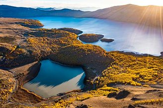
After the summit of Mount Nemrut collapsed and became a crater following large eruptions, smaller ones “leaked” into holes in the eastern half of the caldera. But the other side of the crater, which is not covered with lava, Eventually, it filled with water and formed an inland lake known as Mount Nemrut..
The maximum depth of this lake is approximately 176 m and includes other ancient lava flows from previous eruptions. There are various trails on site where tourists can explore the natural beauty of the landscape.
In the middle of the northern edge of the caldera, there is also a smaller lake, approximately 11 meters deep, fed by hot springs. This shows that although the volcano is dead, it shows signs of activity below its crater.
Did you like the content? So, take the opportunity to explore 4 places on Earth that can be seen from space. To the next one!
Source: Tec Mundo
I’m Blaine Morgan, an experienced journalist and writer with over 8 years of experience in the tech industry. My expertise lies in writing about technology news and trends, covering everything from cutting-edge gadgets to emerging software developments. I’ve written for several leading publications including Gadget Onus where I am an author.


: Everything we know a week after its release")


