


The world landscape we see today was not always as it is. Our planet’s continental configurations are the result of plate tectonics, a driving force that explains the structure and dynamics of the Earth’s surface. Mountain formations, volcanic eruptions, and earthquakes are therefore the result of the movement of rigid plates.
The movement of these blocks of Earth’s lithosphere over a layer of partially molten rock called the asthenosphere causes hot material to rise and cold material to sink. This heat transfer, called convection, occurs at plate boundaries. Like the event that resulted in the formation of the Davis Strait between Canada and Greenland.
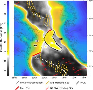
But a recent study published in the journal Gondwana Research found that beneath the strait separating the Labrador Sea from Baffin Bay, A continent, or more precisely a proto-microcontinent, is underwater and is approximately 19 to 24 kilometers long.This piece of continental crust, submerged in deep icy waters, may have emerged almost 61 million years ago.
How did the research reconstruct the formation of the continent?
To understand and explain the causes of this anomaly in the Earth’s crust, two researchers from the University of Derby in the United Kingdom and a researcher from Uppsala University in Sweden, enabled the reconstruction of the tectonic movements of the plates It covers approximately 30 million years during which the protomicrocontinent formed.
In a publication, the team defines the term protomicrocontinent as “regions of thick continental lithosphere separated from the main continents by a relatively thinner region of continental lithosphere.”
To fully test the hypothesis, they used gravity maps and seismic reflection data to determine the orientation and age of faults related to rifting. The geological process in which the Earth’s crust is “stretched” and pulled apart over an extended period of time.
What did scientists discover under the sunken continent?
The researchers found that the break between Canada and Greenland may have begun about 118 million years ago, during the Early Cretaceous period when dinosaurs roamed the Earth. But the seafloor began to expand here about 61 million years ago..
The crucial fact about the formation of the protomicrocontinent, the research says, may have occurred between 49 and 58 million years ago, when the expansion of the sea under the Davis Strait changed direction from northeast-southwest to north-south and stopped completely. . This happened 33 million years ago. When Greenland collides with Ellesmere Island and merges with the North American plate.
The study’s tectonic model accurately detailed the movement after Greenland and Canada separated, revealing the Davis Strait protomicrocontinent as an unusually thick crust in the western Arctic. The model could be used to identify the missing continent, as well as map other microcontinents around the world, according to the authors.
Stay up to date with the latest geophysical discoveries on TecMundo. Or take the opportunity to learn about the hypothetical continent that has become reality, Zealand. Until later!
Source: Tec Mundo
I’m Blaine Morgan, an experienced journalist and writer with over 8 years of experience in the tech industry. My expertise lies in writing about technology news and trends, covering everything from cutting-edge gadgets to emerging software developments. I’ve written for several leading publications including Gadget Onus where I am an author.


: Everything we know a week after its release")


