


A few years ago, archaeologists and geographers theorized that vastly different indigenous tribes inhabited the Amazon thousands of years ago, but until then little had been confirmed on the subject. A new Brazilian study recently published in the journal Science states: Many ancient structures have been found in the region; information was collected using LIDAR technology.
The research team, led by remote sensing scientist and geoprocessing expert Vinicius Peripato from the National Institute for Space Research (INPE), claims to have discovered dozens of disturbances on the surface of an Amazon region. The disturbances are linked to possible architectural structures built by people who supposedly lived in the Amazon thousands of years ago.
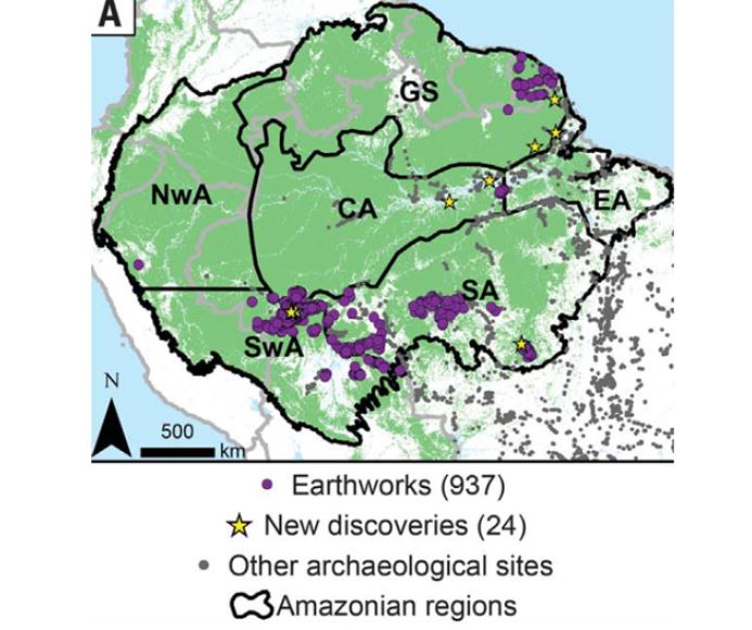
“Indigenous societies are known to have occupied the Amazon basin for more than 12,000 years, but the extent of their impact on the Amazon forest remains unclear. Using basin-wide LIDAR (light detection and ranging) information, we report the discovery of 24 previously undetected pre-Columbian earthworks beneath forest canopy.
What is LIDAR technology?
Light Detection and Ranging, or LIDAR, is a technology that uses lasers to measure information on the surface of an environment; For example, sonar uses sound waves to measure data, while LIDAR uses light lasers. Scientists managed to map the surface of the region using this aircraft-mounted device. and divide it into different parts, revealing vegetation, settlements and possible abandoned villages.
Ancient structures in the Amazon
After analyzing the material, They discovered 24 new archaeological records in the Amazon; Using a 3D model, scientists removed all vegetation from the area studied to facilitate visualization of the ‘findings’; the area represents only 0.08% of the entire Amazon forest.
Vinicius explains that it is still necessary to better understand the extent of pre-Columbian settlement in the region, and there are likely more archaeological sites unknown to science. In all, The paper explored approximately 5,315 square kilometers of data collected by LIDAR.
“The work advances knowledge in three main areas: in archeology itself through new discoveries; To reveal the level of human intervention in environmental sciences that may have impacts on how we shape the current functioning of the region and its future; and finally in the field of applied computing, which allows the analysis of millions of points contained in LIDAR data and the statistical modeling of the distribution of the studied features,” said Luiz Aragon, Department of Earth Observation and Geoinformatics at INPE.
Did you like the content? Stay up to date with the latest scientific studies at TecMundo and take the opportunity to discover how the Sahara Desert benefits the Amazon.
Source: Tec Mundo
I’m Blaine Morgan, an experienced journalist and writer with over 8 years of experience in the tech industry. My expertise lies in writing about technology news and trends, covering everything from cutting-edge gadgets to emerging software developments. I’ve written for several leading publications including Gadget Onus where I am an author.


: Everything we know a week after its release")


